
Using satellites that chase each other, UT researchers have measured changes in Earth’s environment, including rising sea levels, melting ice sheets and changes in land water storage.
Published last month in Journal of Nature Climate Change, the data is being used to study the water cycle, monitor water availability and help agricultural planning, said Srinivas Bettadpur, director of the UT Center for Space Research.
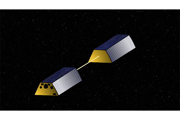
This project, the Gravity Recovery and Climate Experiment mission, took place from 2002 to 2017 and tracked changes in Earth’s gravitational field using two satellites that followed each other in orbit, said research member Clark Wilson.
“Earth’s gravitational field is mainly constant, but it can be affected by shifts in the distribution of air and water over Earth,” said Wilson, a geological sciences professor.
Changes in ocean levels and other major geographical features cause slight variations in the gravitational field, Wilson said.
“(The experiement mission) detects these variations by measuring the distance between the two satellites, which are normally 200 kilometers apart,” Wilson said. “As the satellites pass a geographical feature which affects the gravitational field, the distance between them will change.”
The change is then related back to a geographical feature, such as rising sea level, Wilson said.
Events such as the last Texas drought, Antarctic ice melting and the rise in sea levels were monitored this way, said research member Byron Tapley.
“In the last drought, (the experiment mission) showed that Texas lost around 100 gigatons of water,” said Tapley, an aerospace engineering research professor. “Arctic ice sheets are losing 137 gigatons of ice per year, and sea levels rise by around 3 millimeters per year.”
The Gravity Recovery and Climate Experiment mission showed what is causing sea levels to rise, Tapley said.
“It shows how much of the rise is caused by melting ice sheets and how much is caused by other factors,” Tapley said.
The mission also revealed changes in the gravitational field before and after major earthquakes such as the 2011 Japan earthquake, Tapley said.
Although the experiment mission ended in 2017, a follow-on mission was launched in 2018, said Bettadpur, an aerospace engineering associate professor.
Bettadpur said UT is significantly involved in research to improve gravitational field measurements. One idea is to take measurements from multiple parts of the Earth at once by having multiple pairs of satellites in orbit to provide faster coverage of the Earth, Bettadpur said.
“We hope to use this research to keep making discoveries,” Bettadpur said.