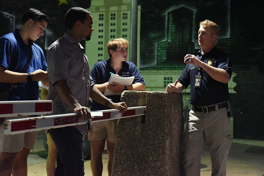
Students should soon be able to see the safest route home, no matter where they are and where they live, said Isaiah Carter, Student Government chief of staff.
Carter — along with a University representative, a City of Austin representative and several SG members — surveyed several blocks of West Campus on Wednesday night as a part of the early process to construct a “safety map” of the area.
“I noticed that we have a high volume of students in West Campus, and as a student who has lived in West Campus as long as I have been at UT, I have always wondered why there isn’t some way for me to make an informed decision on how to get home,” Carter said.
Carter said he plans for the map to highlight areas as safe or less safe to walk through based on anything from lighting to overgrown foliage creating blind spots.
On Wednesday, Carter began the process of creating a metric for other surveyors who are helping him plot the map to follow. The metric is expected to be completed by the end of October, and surveying will begin immediately after through the end of winter break, Carter said.
“The more students that are able to be with me throughout this project, [the] more ideas and more criticism,” Carter said. “I want the map to be as accurate as we can make it so we have the best possible product to deliver to students.”
James Paxton, code inspector with the City of Austin, was also a part of the survey team and said he was brought into the project after hearing concerns about student safety throughout the community.
“Students are always out late into the evening when it might not necessarily be the safest time, so we’re just trying to improve the safety of the area in any way we can,” Paxton said.
Advertising freshman Jodi Nguyen, who lives in West Campus, said she could see herself using the safety map in the future.
“I think that it would be really useful for anybody in general,” Nguyen said. “I feel pretty comfortable on [Guadalupe Street], but past that it’s pretty sketchy and there’s a lot of homeless people, and I know a lot of them don’t mean harm, but after what happened [last April] it’s good to have a reassurance.”
Carter has received support from the University as a part of the process.
Denny Bubrig, associate dean of student life, also participated in the surveying and said the University wanted to support ideas like Carter’s in any way they could, but also wanted him to make the project his own.
“Student safety, generally speaking, is a high priority for us at any time,” Bubrig said. “So when an idea like what Isaiah has comes up, it’s something that can be meaningful in that pursuit. Because of that, we’re going to try to do everything we can do to make that a reality.”